Abstract
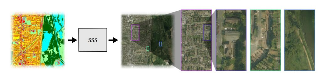
We introduce Seamless Satellite-image Synthesis (SSS), a novel neural architecture to create scale-and-space continuous satellite textures from cartographic data. While 2D map data is cheap and easily synthesized, accurate satellite imagery is expensive and often unavailable or out of date. Our approach generates seamless textures over arbitrarily large spatial extents which are consistent through scale-space. To overcome tile size limitations in image-to-image translation approaches, SSS learns to remove seams between tiled images in a semantically meaningful manner. Scale-space continuity is achieved by a hierarchy of networks conditioned on style and cartographic data. Our qualitative and quantitative evaluations show that our system improves over the state-of-the-art in several key areas. We show applications to texturing procedurally generation maps and interactive satellite image manipulation.
Video playlist:
Congrats to my PhD student Jialin on his first paper. See also model weights and labelled-city code.
On the web
- SSS’s Artificial London was Highly Commended in the British Cartographic Society’s mapping award, Ordnance Survey data category
- The project has been featured at Unite.ai…
- …and New York Tech.
Acknowledgements
We would like to thank Nvidia Corporation for hardware and Ordnance Survey Mapping for map data which made this project possible. This work was undertaken on ARC4, part of the High Performance Computing facilities at the University of Leeds, UK. This work made use of the facilities of the N8 Centre of Excellence in Computationally Intensive Research (N8 CIR) provided and funded by the N8 research partnership and EPSRC (Grant No. EP/T022167/1).
BibTeX
@inproceedings{zhu2021seamless,
title = {Seamless Satellite-image Synthesis},
author = {Jialin Zhu and Tom Kelly},
doi = {https://doi.org/10.1111/cgf.14413},
year  = {2021},
date = {2021-01-01},
booktitle = {Computer Graphics Forum},
volume = {40},
number = {7},
pages = {193–204},
}